
GeoMesa
GeoMesa is an open-source suite for large-scale spatio-temporal data storage, indexing, and analytics on distributed systems like HBase and Spark.
 Tags
Tags
 Useful for
- 1.What is GeoMesa?
- 2.Features
- 2.1.1. Spatio-Temporal Indexing
- 2.2.2. Support for Multiple Data Formats
- 2.3.3. Real-Time Stream Processing
- 2.4.4. Integration with GeoServer
- 2.5.5. Apache Spark Support
- 2.6.6. Open-Source Community
- 2.7.7. Documentation and Resources
- 3.Use Cases
- 3.1.1. Environmental Monitoring
- 3.2.2. Urban Planning
- 3.3.3. Transportation Management
- 3.4.4. Disaster Response
- 3.5.5. Agriculture and Land Use
- 3.6.6. Smart Cities
- 4.Pricing
- 5.Comparison with Other Tools
- 5.1.1. GeoServer
- 5.2.2. PostGIS
- 5.3.3. Apache Flink
- 5.4.4. Google Earth Engine
- 6.FAQ
- 6.1.What types of data can GeoMesa handle?
- 6.2.How does GeoMesa achieve high performance?
- 6.3.Is GeoMesa easy to integrate with existing systems?
- 6.4.Can I use GeoMesa for real-time analytics?
- 6.5.Is there a community for GeoMesa users?
- 6.6.What kind of support is available for GeoMesa?
What is GeoMesa?
GeoMesa is an open-source suite of tools designed for storing, indexing, querying, and transforming spatio-temporal data at scale. It is built to leverage distributed computing systems such as HBase, Accumulo, Cassandra, Redis, Kafka, and Spark. GeoMesa is particularly focused on enabling large-scale geospatial querying and analytics, making it an essential tool for organizations that need to manage vast amounts of geospatial data efficiently.
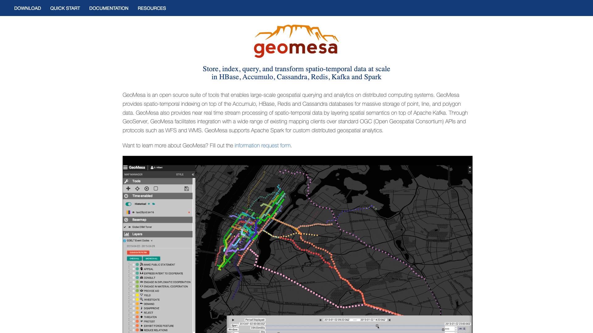
The core functionality of GeoMesa revolves around its ability to provide spatio-temporal indexing, which allows for efficient querying of point, line, and polygon data. This capability is particularly crucial for applications that require real-time analytics and data processing, such as environmental monitoring, urban planning, and transportation management.
Features
GeoMesa offers a robust set of features that make it suitable for a variety of applications involving geospatial data. Some of the key features include:
1. Spatio-Temporal Indexing
GeoMesa provides advanced indexing capabilities that enable fast querying of geospatial data across time and space. This indexing is built on top of popular databases like Accumulo, HBase, Redis, and Cassandra, allowing for efficient storage and retrieval of large datasets.
2. Support for Multiple Data Formats
GeoMesa can handle various data formats, including point, line, and polygon data. This versatility allows users to work with different types of geospatial information without the need for extensive data transformation.
3. Real-Time Stream Processing
By integrating with Apache Kafka, GeoMesa supports near real-time stream processing of spatio-temporal data. This feature is particularly useful for applications that require immediate insights from incoming data streams, such as sensor data and social media feeds.
4. Integration with GeoServer
GeoMesa seamlessly integrates with GeoServer, which allows users to connect with a wide range of existing mapping clients. This integration supports standard OGC (Open Geospatial Consortium) APIs and protocols, including WFS (Web Feature Service) and WMS (Web Map Service).
5. Apache Spark Support
GeoMesa supports Apache Spark for custom distributed geospatial analytics. This capability enables users to perform complex analyses on large datasets efficiently, leveraging the power of distributed computing.
6. Open-Source Community
Being an open-source tool, GeoMesa benefits from a vibrant community of contributors and users. This community-driven approach fosters innovation and provides users with access to the latest features, enhancements, and bug fixes.
7. Documentation and Resources
GeoMesa comes with comprehensive documentation and resources, including a quick start guide, user manuals, and detailed API documentation. This wealth of information helps users get up to speed quickly and make the most of the tool's capabilities.
Use Cases
GeoMesa is highly versatile and can be applied across various industries and domains. Here are some notable use cases:
1. Environmental Monitoring
Organizations involved in environmental monitoring can utilize GeoMesa to analyze geospatial data related to weather patterns, pollution levels, and wildlife movements. The ability to process real-time data streams enables timely decision-making and effective resource management.
2. Urban Planning
Urban planners can leverage GeoMesa to analyze spatial data related to land use, population density, and transportation networks. By integrating various datasets, planners can make informed decisions about infrastructure development and urban growth.
3. Transportation Management
GeoMesa can be used in transportation management systems to monitor traffic patterns, optimize routing, and analyze transit data. The real-time processing capabilities allow for dynamic adjustments based on current conditions.
4. Disaster Response
In disaster response scenarios, GeoMesa can help organizations analyze geospatial data to assess damage, track evacuation routes, and coordinate relief efforts. The ability to integrate multiple data sources enhances situational awareness and response effectiveness.
5. Agriculture and Land Use
Farmers and agricultural organizations can use GeoMesa to analyze soil health, crop yields, and land use patterns. By leveraging geospatial data, they can optimize farming practices and improve sustainability.
6. Smart Cities
GeoMesa can play a crucial role in the development of smart cities by enabling the analysis of data from various sensors and IoT devices. This capability allows city planners to monitor infrastructure, optimize resource allocation, and enhance the quality of life for residents.
Pricing
GeoMesa is an open-source tool, which means it is freely available for anyone to download and use. There are no licensing fees associated with the software itself. However, organizations may incur costs related to infrastructure, such as cloud services or on-premises hardware, depending on their deployment preferences.
For those seeking professional support, GA-CCRi offers commercial support services for GeoMesa. This can be beneficial for organizations that require assistance with implementation, troubleshooting, and performance optimization.
Comparison with Other Tools
When evaluating GeoMesa against other geospatial data processing tools, several factors come into play. Here’s how GeoMesa compares to some popular alternatives:
1. GeoServer
While both GeoMesa and GeoServer focus on geospatial data, their primary functions differ. GeoServer is primarily a web server for sharing geospatial data, while GeoMesa is designed for high-performance geospatial data storage, indexing, and analytics. GeoMesa can integrate with GeoServer, enhancing its capabilities by adding advanced data processing features.
2. PostGIS
PostGIS is a spatial database extender for PostgreSQL that adds support for geographic objects. While PostGIS is a powerful tool for geospatial queries, it may not scale as effectively as GeoMesa when dealing with massive datasets in distributed environments. GeoMesa’s ability to integrate with big data technologies like Apache Kafka and Spark provides an advantage for organizations needing real-time analytics.
3. Apache Flink
Apache Flink is a stream processing framework that can also handle batch processing. While both GeoMesa and Flink can process real-time data, GeoMesa’s focus on geospatial data and indexing provides specialized capabilities for spatio-temporal queries that Flink may not offer out of the box.
4. Google Earth Engine
Google Earth Engine is a cloud-based platform for planetary-scale environmental data analysis. While it offers powerful tools for processing satellite imagery and geospatial data, it may not be suitable for organizations requiring on-premises solutions or those that prefer open-source software. GeoMesa provides a more flexible option for organizations that want to maintain control over their data.
FAQ
What types of data can GeoMesa handle?
GeoMesa can handle various types of geospatial data, including point, line, and polygon data. This versatility allows it to be applied across numerous domains.
How does GeoMesa achieve high performance?
GeoMesa achieves high performance through advanced spatio-temporal indexing and its ability to leverage distributed computing systems. By utilizing technologies like HBase, Accumulo, and Spark, it can efficiently store and query large datasets.
Is GeoMesa easy to integrate with existing systems?
Yes, GeoMesa is designed to integrate seamlessly with existing systems, particularly through its compatibility with standard OGC APIs and protocols. This makes it easier to connect with mapping clients and other geospatial tools.
Can I use GeoMesa for real-time analytics?
Absolutely! GeoMesa supports near real-time stream processing by integrating with Apache Kafka, allowing organizations to analyze incoming data streams and make timely decisions.
Is there a community for GeoMesa users?
Yes, GeoMesa has an active community of users and developers. The project welcomes contributions and provides forums for discussion, making it easy for users to seek help and share knowledge.
What kind of support is available for GeoMesa?
While GeoMesa is an open-source tool and free to use, GA-CCRi offers professional support services for organizations that require assistance with implementation and troubleshooting.
In conclusion, GeoMesa stands out as a powerful solution for organizations looking to manage and analyze large volumes of geospatial data. Its combination of advanced indexing, real-time processing capabilities, and integration with popular distributed computing systems makes it a valuable tool for a wide range of applications. Whether for environmental monitoring, urban planning, or disaster response, GeoMesa provides the tools necessary to harness the power of geospatial data effectively.
Ready to try it out?
Go to GeoMesa